

Gerrymandering is not an American invention, even if the name and most of the famous maps are. Wherever seats are won district by district and the people who benefit get to draw the districts, it appears. Most democracies have it in their past. The difference is that most of them quietly removed one of those two conditions, and the United States never did.
Northern Ireland: Derry, 1966
The textbook case is a city council. In 1966 Derry had 14,429 Catholic electors and 8,781 Protestant ones, and a council of 20 seats that Unionists controlled 12 to 8. The trick was three wards. The South Ward packed 10,047 Catholic electors, nearly nine in ten of them, into a ward that elected eight councillors. The North Ward and the Waterside, each with a modest Protestant majority, elected the other twelve. A two-thirds majority of voters, a permanent minority on the council.
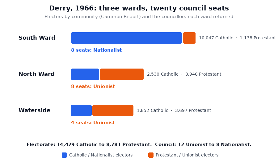
The map was one of the grievances that started the civil rights movement, under the slogan "one man, one vote". The government dissolved the corporation in 1969 and replaced it with an appointed commission; the Cameron Report, the official inquiry into that year's disturbances, called the ward arrangement what it was.
Ireland: the Tullymander that backfired
Ireland elects several members per constituency by transferable vote, which makes gerrymandering harder but not impossible: the lever is how many seats each constituency gets. In 1974 James Tully, the minister responsible, redrew Dublin into three-seat constituencies calculated so that the governing Fine Gael–Labour coalition would take two of every three. The press named it the Tullymander.
At the 1977 election the swing went the other way. Fianna Fáil's vote in Dublin passed the coalition's, and every constituency drawn to split two-to-one split two-to-one against its authors. Fianna Fáil won 84 seats, the largest majority in the history of the state. Ireland has drawn its constituencies through an independent commission ever since.
Queensland: the Bjelkemander
Australia's version was less about shapes than about sizes. Under Premier Joh Bjelke-Petersen, Queensland divided its electorates into zones, and a seat in the rural west could hold half as many voters as a seat in Brisbane. Fewer voters per seat means more seats per voter: the countryside, which voted for his National Party, was worth double. At the 1986 election the Nationals won 49 of 89 seats with 39.6 percent of the vote.
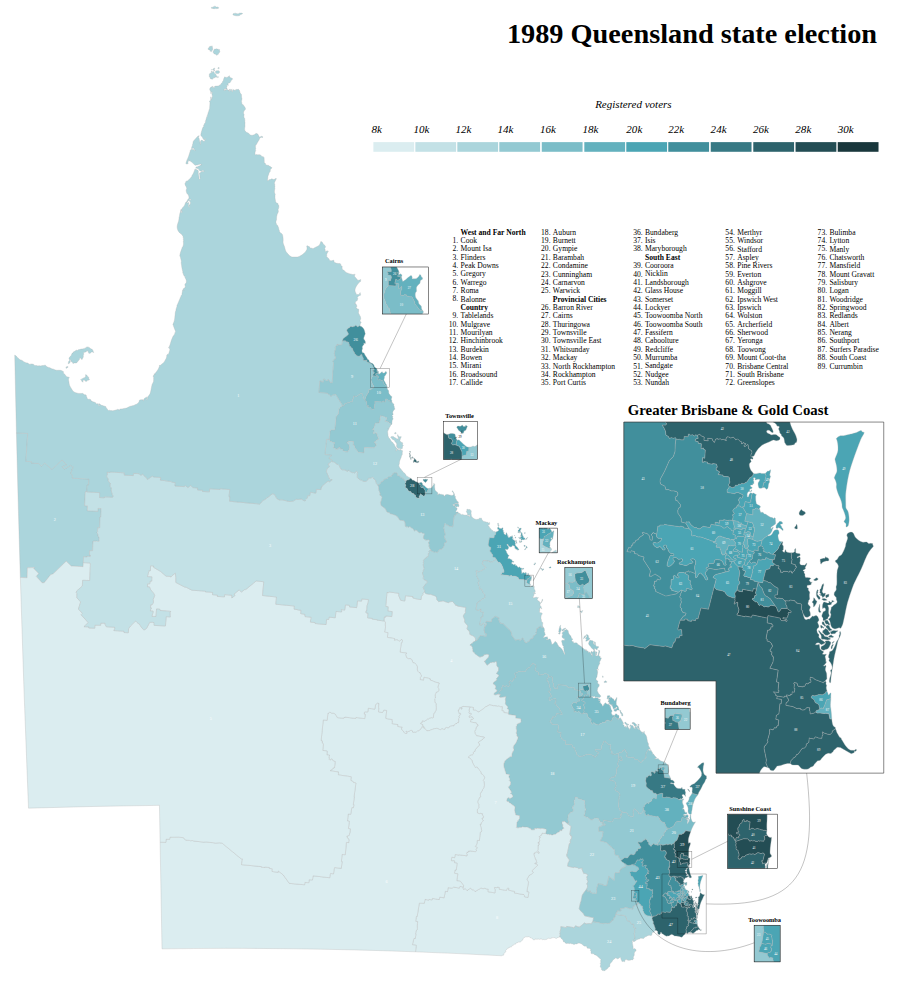
A corruption inquiry brought the government down in 1989, and the reforms that followed handed the boundaries to an independent commission and abolished the zones.
Hungary: the 2011 map
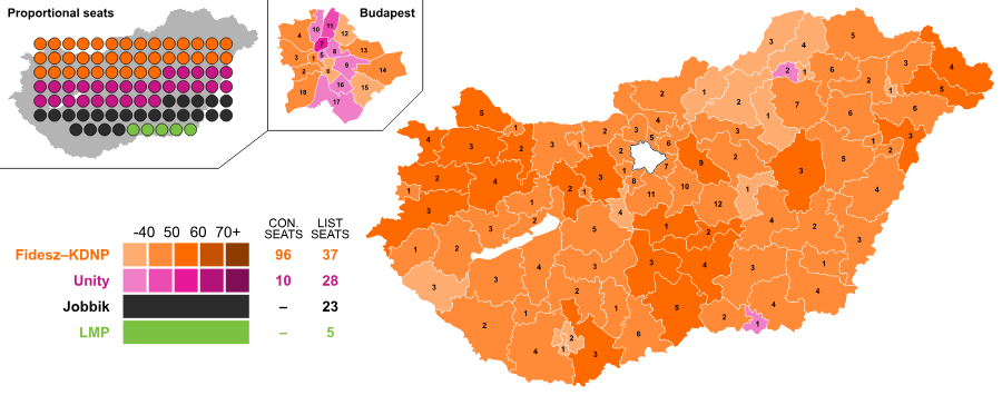
Fidesz won a two-thirds majority in 2010 and used it to rewrite the electoral law, cutting the single-member constituencies from 176 to 106 and drawing the new ones itself. At the next election, in 2014, the party took 45 percent of the list vote and 96 of the 106 constituencies, enough for two-thirds of parliament again. Opposition voters were concentrated in a handful of Budapest seats and spread thin everywhere else.
Malaysia: one vote, ten votes
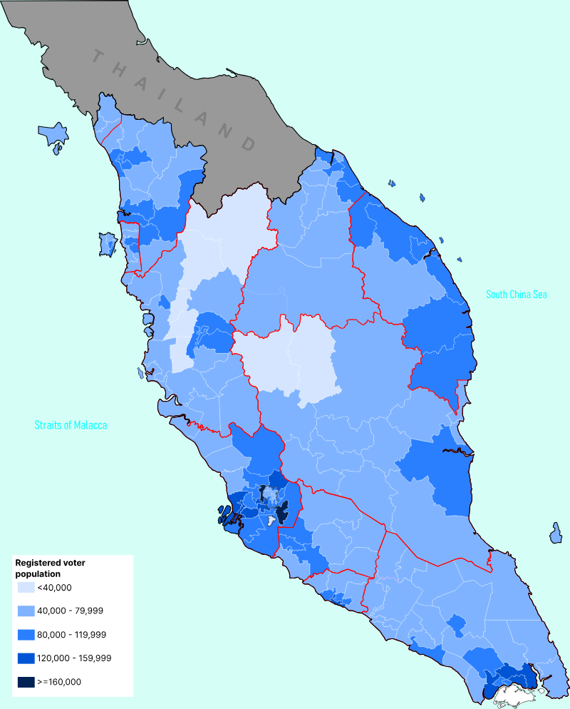
Malaysia combines both tools. Its constituencies vary in size more than almost any democracy's, with some seats holding ten times the voters of others, and the small ones sit in the rural areas that supported the long-ruling coalition. In 2018 the Election Commission redrew the lines weeks before the election. It did not save the government: the coalition lost power for the first time since independence, a reminder that a rigged map moves the odds, not the certainty.
Why the United States gets more of it
Four things line up in America that rarely line up elsewhere.
Every seat is a district. Congress, state legislatures, county boards: almost everything is elected one winner per district. Most of Europe elects parliaments proportionally, so a party's seats track its votes and the lines barely matter; Germany and New Zealand mix districts with list seats that cancel out any distortion. Where there are no lines to draw, there is nothing to gerrymander.
The politicians hold the pen. In most states the legislature draws the map and the governor signs it. The United Kingdom, Canada, Australia and Ireland all hand the job to independent commissions, most of them created after a scandal like the ones above. About a dozen American states have commissions; the rest do not.
The lines are always moving. Since the 1960s the Supreme Court has required districts of equal population, so every map must be redrawn after every census, and nothing stops a legislature redrawing in between. Each redraw is a chance. Commissions elsewhere redraw on a fixed schedule with fixed rules.
Nobody stops it. In 2019 the Supreme Court ruled that federal courts cannot police partisan gerrymanders at all. Only state courts and state constitutions can, and only in the states that have chosen to.
The countries above all fixed it the same way: after one map too many, they took the pen away from the people it helped. That is the reform every American proposal comes back to.
Sources
- Disturbances in Northern Ireland (the Cameron Report), HMSO (1969)
- Museum of Free Derry: Population changes and gerrymandering
- The Irish Times: Some of Ireland's three-seater constituencies were drawn up to keep Fianna Fáil out of government (13 Jun 2026)
- ANU: Electoral malapportionment, partisanship, rhetoric and reform in the shadow of the agrarian strong-man
- 1986 Queensland state election
- OSCE/ODIHR: Hungary parliamentary elections 6 April 2014, final report
- Registered voters by constituency, Peninsular Malaysia (2018 data), Wikimedia Commons