

The short answer
Gerrymandering is drawing electoral district boundaries so that one party wins more seats than its share of the vote. Every vote is counted fairly at the ballot box. The trick happens earlier: whoever draws the map decides which voters are grouped together, and the grouping decides most contests before anyone has voted.
Packing and cracking
A gerrymander is built from just two moves: packing and cracking. Packing crams your opponents into a few districts they win by a landslide, wasting their votes on margins they didn't need. Cracking splits the rest of them across many districts so they fall just short in each one. Everything else is detail.
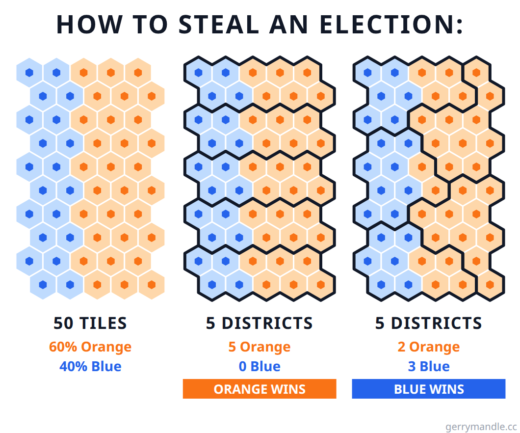
Run both at once and the seats come loose from the votes: a party with a minority of the vote can take a comfortable majority of the seats, and hold it through elections it keeps losing. Geography can do it without help, too. Winning a district means having a majority somewhere, and Massachusetts Republicans have one nowhere: they reliably win about a third of the vote, spread almost evenly across the state, and have not elected a US House member since 1994. Any district you could draw inherits roughly the same one-third mix, and mathematicians have shown that for some recent elections, no possible nine-district map would have produced even one Republican seat.
Where the word comes from
In 1812, Massachusetts governor Elbridge Gerry signed a redistricting bill with a state senate district so contorted that the Boston Gazette dressed it in wings and claws and called it the "Gerry-Mander", after the salamander it resembled.
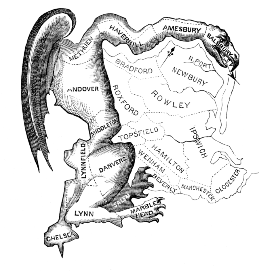
The cartoon stuck, and so did the district: Gerry's party held the senate seats the map was drawn to hold, even as Gerry himself lost re-election that autumn. The practice is older than the name. Patrick Henry drew Virginia's first congressional map hoping to keep James Madison out of Congress. Madison won anyway. Today the mechanics are unchanged, but algorithms model thousands of map variants and tune each district with surgical precision.
Does gerrymandering still happen?
Constantly. North Carolina is the clearest case study. Presidential races there are decided by a point or three; the congressional map never is. The architect of the 2016 map announced his goal in the open: ten Republicans and three Democrats, only because he could not draw a map for eleven.
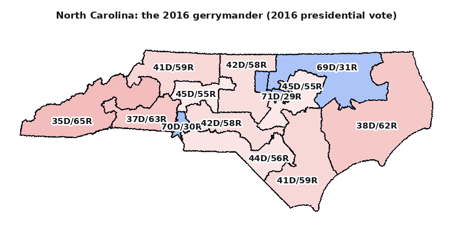
In 2019 the US Supreme Court examined that very map (Rucho v. Common Cause) and ruled that federal courts cannot police partisan gerrymanders at all, even while calling gerrymandering "inconsistent with democratic principles". State courts kept trying. They forced a fairer map, and in 2022 the state elected seven Democrats and seven Republicans.
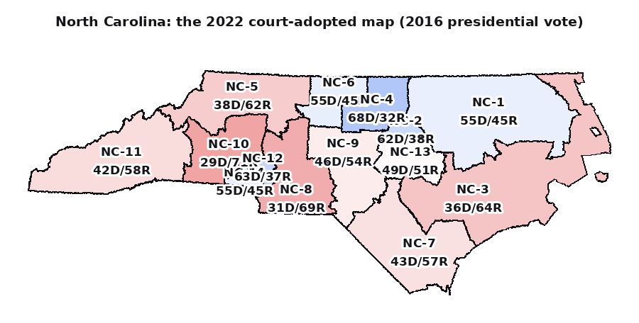
Then the state supreme court changed hands, the legislature redrew the lines mid-decade, and in 2024 the same closely divided state returned ten Republicans out of fourteen. The votes barely moved. The lines did.
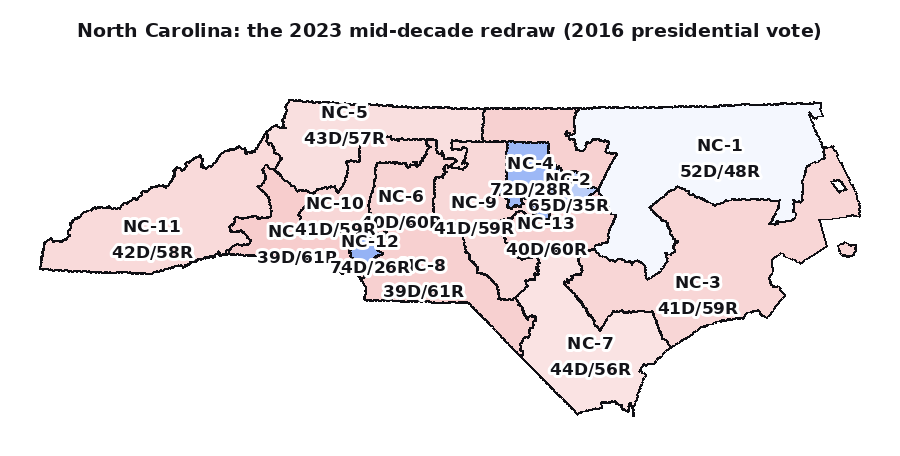
And it is speeding up. Redistricting used to happen once a decade, after the census. Since 2020, more than a quarter of all congressional seats have been redrawn mid-decade. Texas redrew in 2025 to add five Republican seats; California answered by suspending its independent commission and redrawing its own map; Virginia and Florida followed. A 2026 Supreme Court ruling raised the bar further, requiring proof of discriminatory intent rather than discriminatory effect, which makes even racial gerrymanders far harder to challenge. Redistricting has become an ongoing political instrument.
Can it be fixed?
The fixes are known; none of them are self-executing. Independent commissions take the pen away from the politicians whose seats are on the map. Michigan's voters created one by ballot initiative in 2018, and Arizona and California have drawn with them for years, though California's suspension shows a commission lasts only as long as the politics around it. Some state constitutions have teeth of their own: Pennsylvania's supreme court threw out its congressional map in 2018 under the state's free-elections clause. And structural changes, like multi-member districts with proportional rules, would make the lines barely matter, which is precisely why they are rarely adopted. The pattern is consistent: gerrymandering gets fixed exactly where the people who benefit from it lose the power to block the fix.
Try it yourself
The fastest way to understand gerrymandering is to commit some. Start with the real maps: actual gerrymanders from US history, built from real precinct data, including the North Carolina map above. This time you hold the pen. Never played? The interactive tutorial teaches the basics in two or three minutes.
Play the real mapsThen try the daily puzzle: a small map, a few parties, and the job of drawing the districts so your side wins the election. Less realistic, more fun. A new puzzle is published every day, and everyone gets the same one.
Play today's puzzle