

Rigging district lines is older than the United States. English parliamentary seats were notoriously lopsided for centuries: the "rotten borough" of Old Sarum, an uninhabited hill, elected two members of Parliament while the city of Manchester elected none. The first American congressional elections inherited the habit. In 1788, Patrick Henry drew Virginia's first congressional map to keep James Madison out of Congress, packing his home county in with places thought to be hostile to him. Madison won anyway, and went on to help write the Bill of Rights.
1812: the salamander
The name arrived a generation later. In 1812, Massachusetts governor Elbridge Gerry signed a redistricting bill drawn to keep his party in control of the state senate. One Essex County district was so contorted that the Boston Gazette dressed it in wings and claws and called it the "Gerry-Mander", after the salamander it resembled.
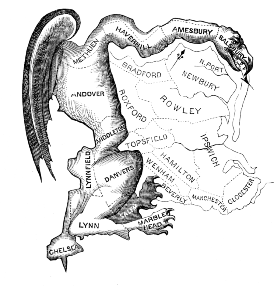
The map worked and its author paid for it anyway: Gerry's party held the senate seats the district was drawn to hold, while Gerry himself lost re-election that autumn. He landed on his feet, becoming vice president the next year under James Madison, the man the first congressional gerrymander had been aimed at.
The frozen-map century
Through the nineteenth century, partisan mapmaking was simply how redistricting worked: whichever party held a legislature drew the lines to keep holding it. Then many states discovered a quieter trick: stop drawing altogether. As Americans moved to the cities, legislatures dominated by rural seats just kept the old maps. Tennessee did not redraw its state legislature between 1901 and 1962, by which point some city districts held roughly ten times the population of rural ones: ten times the voters, the same one seat. No lines were bent. The map cheated by standing still.
One person, one vote
That Tennessee map produced the modern law of redistricting. In Baker v. Carr (1962), the US Supreme Court ruled that courts could hear redistricting cases at all, and within two years (Wesberry v. Sanders and Reynolds v. Sims, both 1964) it required districts of equal population at every level: one person, one vote. The Voting Rights Act of 1965 added a second guardrail, outlawing maps that dilute the votes of racial minorities.
The reform carried an irony. Equal population means new maps after every census, so every state now redistricts every decade, on schedule. The rules ended frozen maps and rotten boroughs, and in exchange they handed every mapmaker a regular, legally required opportunity to draw the lines their way.
The computer era
For decades the Supreme Court circled the remaining problem, the purely partisan gerrymander, without touching it: justiciable in principle in 1986, but no case ever produced a standard the court would accept. Into that opening stepped the modern map war. In 2010, the Republican State Leadership Committee's REDMAP project spent some thirty million dollars on state legislative races, timed to the census, precisely because those legislatures would draw the next decade's maps. It worked: in 2012, Democratic candidates for the US House won about 1.4 million more votes nationwide, and Republicans kept a 33-seat majority.
The tools had caught up with the ambition. Precinct-level data and modern software let mapmakers test thousands of variants and tune each district with surgical precision. The moves are still the ones Elbridge Gerry's party used: packing and cracking. The difference is that nobody has to guess anymore.
The courts step back
State courts still police their own maps now and then: Pennsylvania's supreme court threw out its congressional map in 2018 under the state constitution's free-elections clause. But in 2019 the US Supreme Court closed the federal courthouse door. In Rucho v. Common Cause, examining North Carolina's map, it ruled that partisan gerrymandering claims are beyond the reach of federal courts, even while calling the practice "inconsistent with democratic principles". What happened to North Carolina's map after that is a story of its own, told with pictures in What is gerrymandering?.
The permanent map war
Redistricting used to happen once a decade, after the census. No longer. Since 2020, more than a quarter of all congressional seats have been redrawn mid-decade. Texas redrew in 2025 to add five Republican seats; California answered by suspending its independent commission and redrawing its own map; Florida, Missouri, Ohio and North Carolina followed. A 2026 Supreme Court ruling raised the bar for challenges further, requiring proof of discriminatory intent rather than discriminatory effect. Two centuries after the salamander, the lines have never moved more often, or more deliberately.